Ellipsoidal Coordinate System
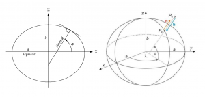
The Earth’s shape can be approximated well enough by a rotational ellipsoid with flattened poles. Such an ellipsoid is created by rotating a meridian ellipse about its minor axis. It is defined by two geometric parameters: the semi-major axis a and semi-minor axis b (Figure 2). Ellipsoidal coordinates are defined by latitude and longitude (φ ,λ). Latitude is the angle measured in the meridian plane between the equatorial plane (xy-plane) of the ellipsoid and the surface normal at the arbitrary point P. Longitude is the angle measured in the equatorial plane between the reference meridian (passing through the x-axis) and the meridian plane of the point. Latitude and longitude are positive northward and eastward, respectively. The height h is defined as the distance between a point on the physical surface of the earth and the ellipsoid measured along the normal of the ellipsoid passing through the point P. The 3 components of position are often referred to as geodetic coordinates, ellipsoidal coordinates, or geographic coordinates.

Figure 2. (A) Meridian ellipse, and (B) ellipsoidal coordinates